Aéroport international Léopold Sédar Senghor
ABOUT US
Mon - Fri, 2022
7:30 AM – 3:30 PM
Immeuble San Marco
BP 8163 Dakar - Sénégal
+221 33 865 40 27
Contact@satnav-africa.org
Mon - Fri, 2022
7:30 AM – 3:30 PM
Immeuble San Marco
BP 8163 Dakar - Sénégal
+221 33 865 40 27
Contact@satnav-africa.org

The Global Navigation Satellite Systems in operation today have a number of limitations, an example of which is their inability (due to errors associated with the reception of GNSS signals) to meet the stringent requirements of some applications in terms of accuracy, integrity, continuity and availability.
SBAS, an acronym which stands for Satellite Based Augmentation System, overcomes these limitations by providing error correction messages via Geostationary Satellites to the users of primary GNSS services. The ability to provide such services makes SBAS compliant with the stringent requirements of specific applications such as Aviation navigation services, whose operational requirements are set by the International Civil Aviation Organization (ICAO) for use during the most critical phases of aircraft flight.
Choose one of your services
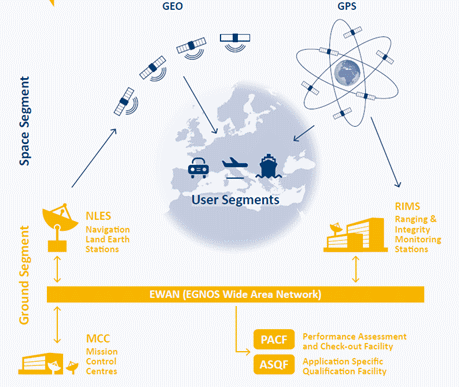
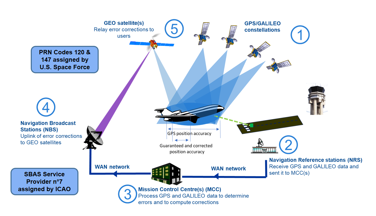
Typically, SBAS infrastructure comprises the following elements;
Satellite Based Augmentation Systems have been implemented or are undergoing implementation in several parts of the world. The WAAS (USA), EGNOS (Europe), MSAS (JAPAN) and GAGAN (India) are in operation while SDCM (Russia), KASS (South Korea), BDSBAS(China), SouthPAN (Australia) and ASECNA A-SBAS in Africa are either under development and deployment. These systems are as shown in the map below.
The European Geostationary Navigation Overlay Service (EGNOS) is Europe's regional Satellite-Based Augmentation System that is used to improve the performance of Global systems such as GPS and Galileo. EGNOS uses GNSS measurements taken by accurately located reference stations to measure GNSS errors which are then transferred to a central computing centre, where differential corrections and integrity messages are calculated. These corrections, which serve as an augmentation, or overlay to the original GNSS message are then broadcast over the coverage area using Geostationary satellites.
As a result, EGNOS improves the accuracy and reliability of GNSS positioning information, while also providing a crucial integrity message regarding the continuity and availability of a signal.
There are three EGNOS services that are currently provided in Europe and these are:
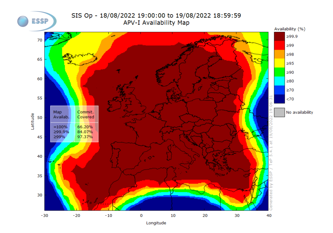
EGNOS supports En-route, Terminal and Approach operations and has been approved for LPV-200 service since 2015 with first approach performed in 2016. Over 694 LPV approaches have been published at a total of 293 airports
For more information click here.
The Wide Area Augmentation System (WAAS) is owned and operated by the Federal Aviation Administration (FAA) and has a coverage over the Continental United States (CONUS), Alaska, Canada and Mexico. It is used to improve the accuracy of the Global Positioning System (GPS) and with such capabilities on board an aircraft, pilots are authorized to fly throughout the United States without reliance on ground-based navigation aids. WAAS provides its service for all classes of aircraft in all phases of flight including en route navigation, airport departures, and airport arrivals (vertically-guided landing approaches).
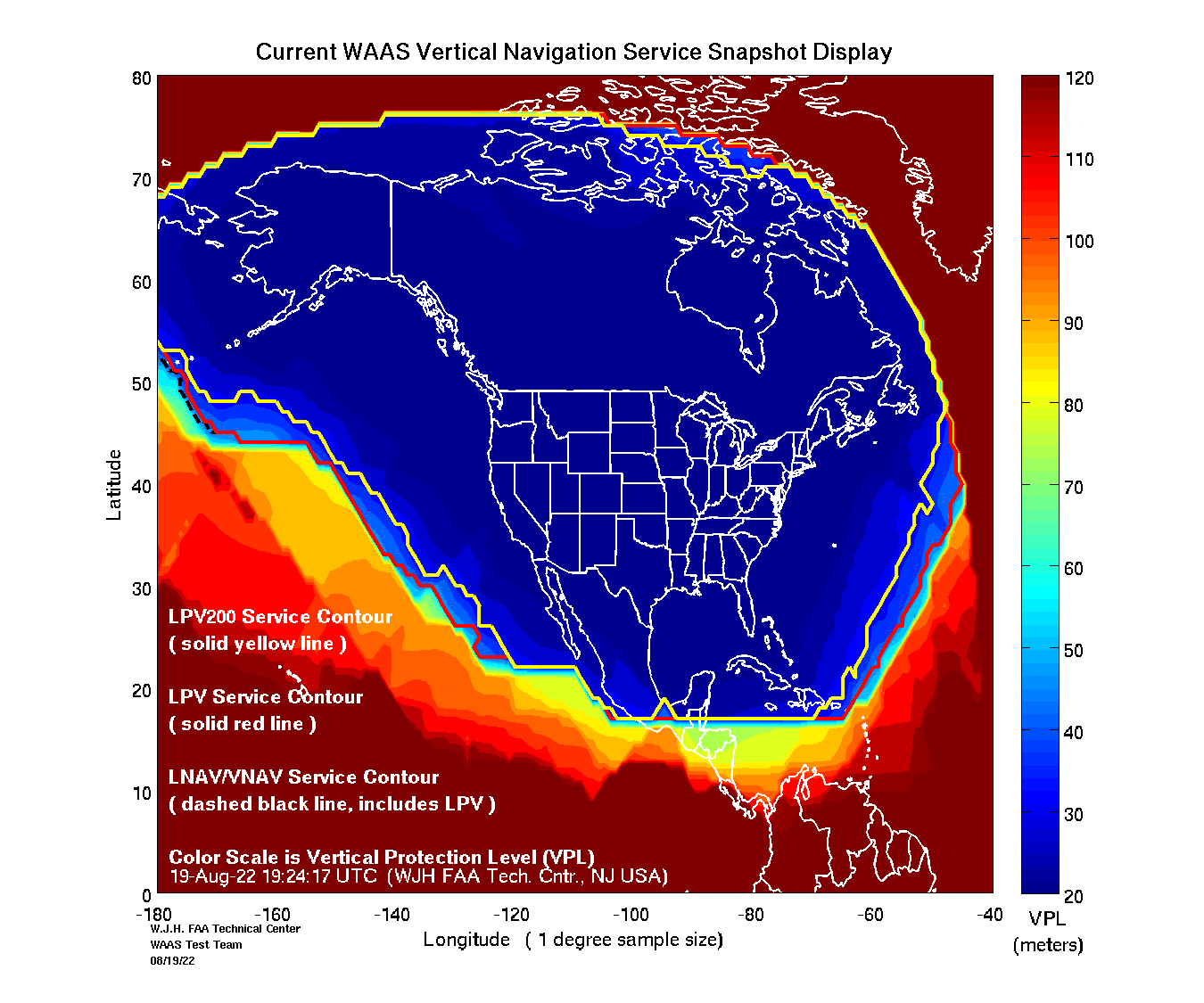
An example of SBAS coverage from WAAS is as shown. The system has been in place since 2003 and supports en-route, terminal and approach air navigation operations. It has over 4,789 published LP and LPV approaches at 1,779 airports and at least 131,000 aircraft equipped with WAAS capabilities.
For more information click here.
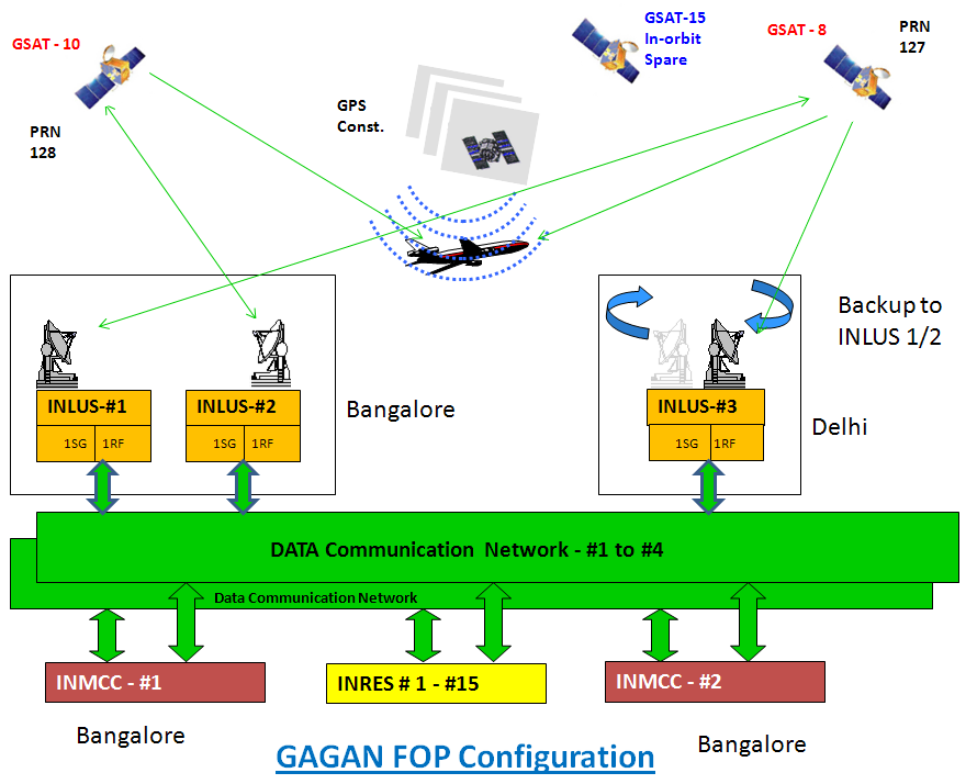
GAGAN is India’s SBAS system jointly developed by the Indian Space Research Organisation (ISRO) and the Airports Authority of India (AAI) to provide improved navigational services over the Indian FIR (Flight Information Region) with the capability of expanding to neighbouring FIRs.
GAGAN provides a civil aeronautical navigation signal consistent with International Civil Aviation Organization (ICAO) Standards and Recommended Practices (SARPs) as established by the Global Navigation Satellite System (GNSS) Panel. The GAGAN system provides a Non-Precision approach (NPA) service accurate to within the radius of 1/10th of a nautical mile (Required Navigation Performance or RNP-0.1) over the Indian FIR as well as precision approach service of APV-1.0 (Approach with Vertical guidance) over the Indian landmass on nominal days. RNP 0.1 certification was declared in December 2013 while the APV 1 certification declared in April 2015.
The system is interoperable with other international SBAS systems such as the WAAS, EGNOS and MSAS and provides seamless air navigation across regional boundaries.
For more information click here.
China is developing its BeiDou Satellite-Based Augmentation System (BDSBAS) in accordance with International Civil Aviation Organization (ICAO) Standards and Recommended Practices (SARPs), and it has provided initial Single Frequency (SF) and Dual-Frequency Multi-Constellation (DFMC) services since July 2020.
It is aimed to serve users in China and surrounding areas and aims to achieve Approach with Vertical Guidance I (APV-I) and CAT-I precision approach capabilities.
China Satellite Navigation Office (CSNO), Civil Aviation Administration of China (CAAC) and China Satellite Navigation Project Center (CSNPC) are collaborating actively in promoting the construction and application of BDSBAS.
Since 2012 China has been carrying out BDSBAS system design and system demonstration as well as tests and verifications of SF SBAS technology. Since2015, DFMC SBAS technology tests and verifications have been carried out and China has begun to select and construct ground monitoring stations and is actively participating in the development of SBAS international standards.
The first BDSBAS Geosynchronous Earth Orbit (GEO) satellite was successfully launched in November 2018, and BDSBAS system integration and testing have been underway since then.
For more information click here.
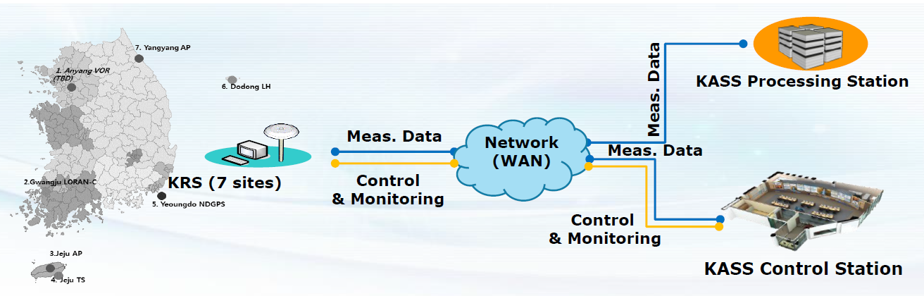
The KASS is South Korea’s SBAS which was launched in 2013 and is currently being developed under the management of Korea Aerospace Research Institute (KARI). It is foreseen to increase positioning accuracy and reliability so as to enhance aviation, transportation, surveying, timing, unmanned aerial systems (UAS) and other industries in the region. In relation to its support for the aviation community, it is foreseen to be the primary means of navigation service for all phases of flight, namely from en-route through precision approach.
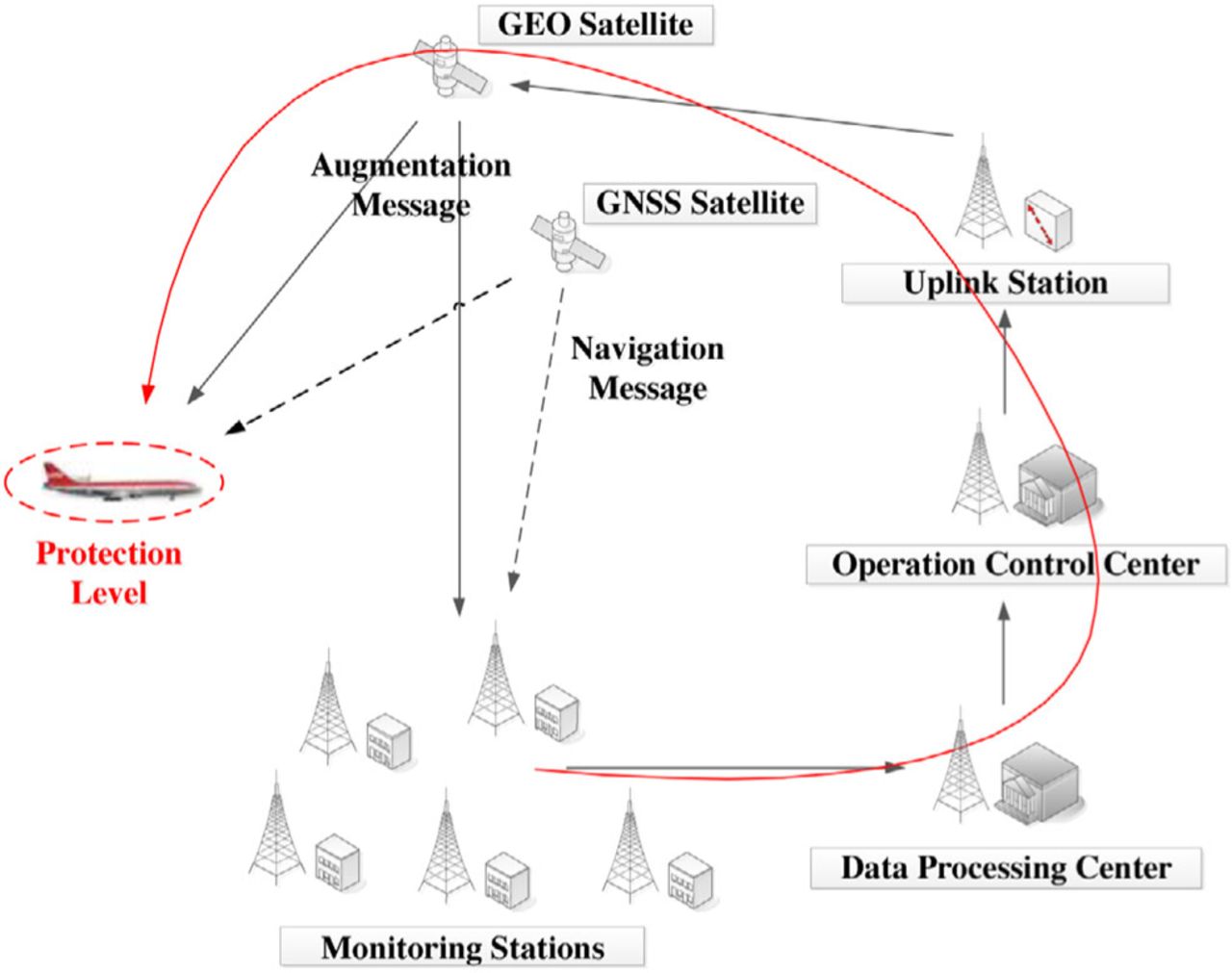
As depicted in the figure, the KASS acquires GPS and GEO measurement from KASS Reference Stations KRS and transmits the data to the KASS Processing Station (KPS) and the KASS Control Station (KCS) for the generation of SBAS corrections. The generated SBAS correction messages are transmitted to the user via the KASS Uplink Station (KUS) and the corresponding Geostationary satellites.
ASECNA conducted flight demonstrations at Lomé Gnassingbe Eyadéma International Airport, in January 2020, providing the opportunity to showcase on ground the benefits of SBAS operations, in terms of safety improvement, operational costs reduction, and environmental protection. In June 2021, a successful SBAS demonstration flight between Douala and Kribi in Cameroon with a rotorcraft. The rotorcraft carried out a low-altitude, two-way demonstration flight along a low-level route linking two Point-in-Space (PinS) approaches to the Douala airport and a point near the oil platforms off the Kribi coast.
In July 2021, a successful demonstration of the ANGA additional services (Precise Point Positioning- PPP and early warning services) was conducted in Congo Brazzaville.
For more information click here.
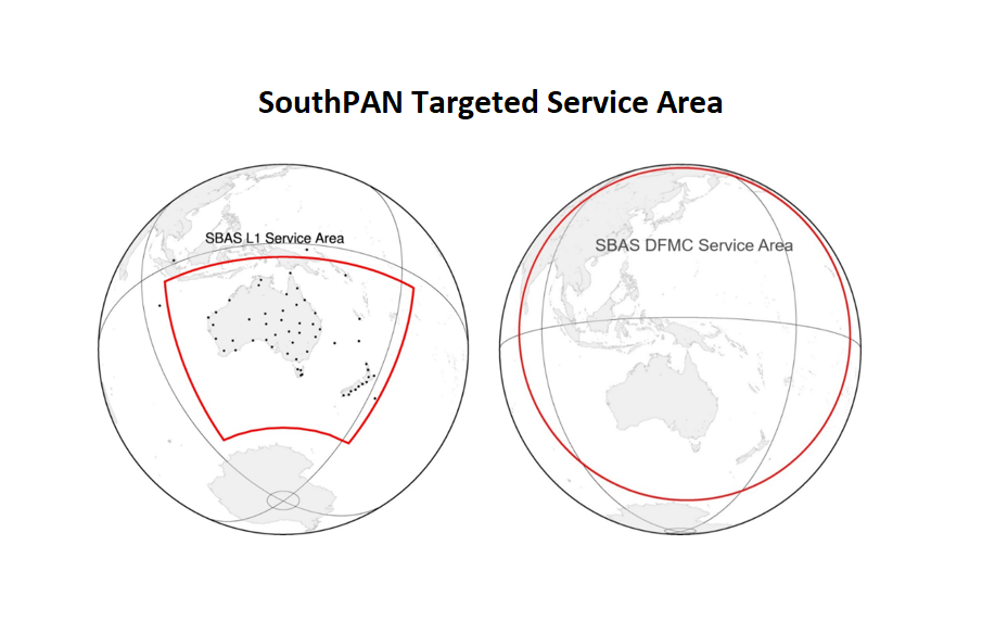
The SouthPAN is the planned joint New Zealand/Australia Satellite Based Augmentation System (SBAS). The two countries are working together to bring this world-leading technology to their region, joining other countries that have successfully invested in SBAS capabilities. The project is led by Geoscience Australia and Land Information New Zealand (LINZ) under the Australia –New Zealand Science, Research and Innovation Cooperation Agreement.
The plan to develop the SouthPAN was an outcome of an 18 months SBAS trial project that commenced in 2017 and had successful trials that tested 27 projects across a range of sectors such as aviation, construction, surveying and mapping. The targeted service area by the project is as shown in the figure below.
For more information refer to ICAO NSP Meeting, Montréal, 17 – 27 April 2018 or click here.
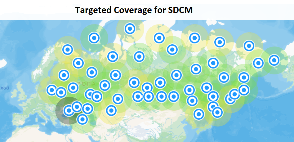
The System for Differential Corrections and Monitoring (SDCM) is the SBAS currently being developed by Russia as a component of GLONASS, its core GNSS. It is Intended to perform integrity monitoring of both GPS and GLONASS satellites as well as provide differential corrections.
The targeted services to be provided to the aviation community are NPA (non-precision approach), APV-Ⅰ and APV-Ⅱ (Approach with vertical guidance of categories Ⅰ and Ⅱ). Broadcasting of SDCM signals is carried out continuously via geostationary satellites of the MKSR LUCH: Luch-5B (16°W, PRN 125) and Luch-5V (95°E, PRN 140).
For more information click here.
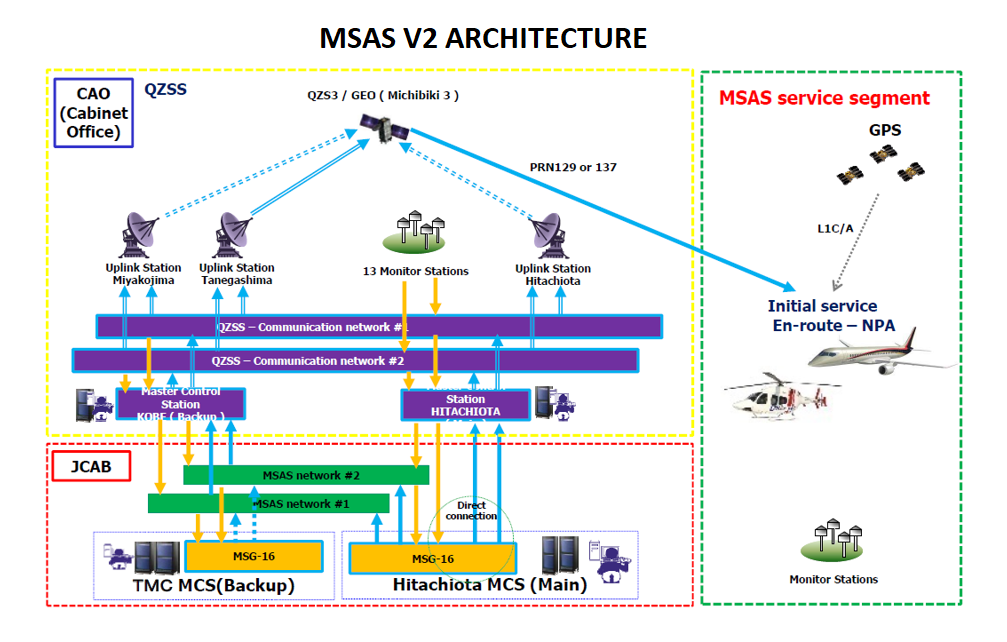
MSAS is an SBAS that provides augmentation services to Japan. It is provided by the Japanese Civil Aviation Bureau (JCAB). It uses two Multi-Functional Transport Satellites (MTSAT) and a network of ground stations to augment GPS signals in Japan. It was declared operational in 2007 and provides horizontal guidance within the MSAS service volume and supports En-route, Terminal and Non-Precision Approach operations.
The current system configuration of the system is as shown. There are over 140 SBAS equipped aircraft (100 general aviation, 40 airline), with expectation to increase to over 190 total equipped aircraft by 2023 following delivery of Mitsubishi Regional Jets.
For more information click here.

")